Overview
The Earth configuration workspace defines how the planet Earth is modeled internally by SatModeler during a simulation.
Within this workspace, users select the physical and environmental models used to represent the Earth’s atmosphere, gravity field, and magnetic field. These models provide the physical foundation for all Earth-related computations performed by the simulation engine.
The selected models directly affect:
- Orbital propagation accuracy
- Aerodynamic force and torque computation
- Magnetic field interactions and magnetic torque effects
- Long-term orbit evolution
This configuration is typically set once per mission and applies globally to all spacecraft simulated within the environment.
Main Features
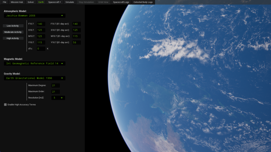
Atmospheric Model
SatModeler currently implements the Jacchia–Bowman 2008 (JB2008) atmospheric model, a high-fidelity empirical model referenced by ECSS (European Cooperation for Space Standardization) for atmospheric density modeling.
The atmospheric model is used to compute atmospheric density, which is required for the calculation of aerodynamic forces and torques acting on the spacecraft.
Jacchia–Bowman 2008 parameters
The JB2008 model relies on solar and geomagnetic activity indices. SatModeler provides preset configurations corresponding to low, moderate, and high solar and geomagnetic activity conditions.
Key parameters include:
- F10.7
Solar radio flux index at 10.7 cm wavelength, commonly used as a proxy for solar activity.
Higher values generally increase thermospheric density. - S10.7
Extreme ultraviolet (EUV) solar index, improving density estimation compared to using F10.7 alone. - M10.7
Modified solar index accounting for delayed solar effects on the upper atmosphere. - Y10.7
Index representing semiannual variations in solar heating. - 81-day averages
Smoothed versions of the indices used to capture long-term solar trends. - dTc (ΔTc)
Correction term applied to the exospheric temperature. This term indirectly reflects the impact of geomagnetic disturbances and solar storm activity on atmospheric density.
Choosing higher activity levels results in increased atmospheric density, leading to stronger aerodynamic forces and torques, and faster orbital decay, especially for spacecraft operating below approximately 800 km altitude.
More atmospheric models will be released in subsequent versions of SatModeler.
Magnetic Field Model
SatModeler supports multiple global geomagnetic field models used to compute the Earth’s magnetic field vector at any point in space.
Available models include:
- International Geomagnetic Reference Field 13 (IGRF13)
- International Geomagnetic Reference Field 14 (IGRF14)
- World Magnetic Model 2020 (WMM2020)
- World Magnetic Model 2025 (WMM2025)
Model differences
International Geomagnetic Reference Field (IGRF)
The International Geomagnetic Reference Field is a scientific reference model maintained by the geomagnetic research community. It is updated periodically and is typically used for high-accuracy scientific and research simulations.
The validity of each IGRF release is limited to a specific time span:
- IGRF13
Valid for dates between 1900 and 2030. For dates between 2020 and 2030, the model relies on predictive coefficients and therefore provides an approximation of the geomagnetic field.
Magnetic field values are not computed outside this interval. - IGRF14
Valid for dates between 1900 and 2035. For dates between 2025 and 2035, the model uses predictive coefficients and returns an approximate representation of the geomagnetic field.
Magnetic field values are not computed outside this interval.
World Magnetic Model (WMM)
The World Magnetic Model is an operational geomagnetic field model widely used in aerospace, navigation, and defense applications. It is optimized for engineering and operational use cases, particularly where robustness and standardization are required.
Each WMM release is designed for a specific operational period:
- WMM2020
Operationally valid for dates between 2020 and 2025.
While the model can return magnetic field values outside this range, the accuracy progressively degrades as the simulation date diverges from its nominal validity period. - WMM2025
Operationally valid for dates between 2025 and 2030.
As with previous releases, magnetic field values can be computed outside the nominal range, but with decreasing accuracy as the date moves further from the model’s intended epoch.
Newer model versions (e.g., IGRF14 and WMM2025) incorporate more recent observational data and generally provide improved accuracy for simulations within their respective validity periods.
| Model | Recommended simulation dates | Notes |
|---|---|---|
| IGRF13 | 1900–2030 |
2020–2030: predictive coefficients (approximation). Outside 1900–2030: magnetic field is not computed. |
| IGRF14 | 1900–2035 |
2025–2035: predictive coefficients (approximation). Outside 1900–2035: magnetic field is not computed. |
| WMM2020 | 2020–2025 |
Designed for operational use in 2020–2025. Outside this range, accuracy degrades progressively. |
| WMM2025 | 2025–2030 |
Designed for operational use in 2025–2030. Outside this range, accuracy degrades progressively. |
The selected magnetic field model affects not only magnetic field vector computation but also magnetic torque calculations, including interactions with the spacecraft’s residual magnetic dipole.
Gravitational Model
Earth’s non-uniform gravity field is modeled using spherical harmonic expansions derived from the Earth Gravitational Model (EGM) family. These models account for deviations from a perfect spherical gravity field and are essential for accurate orbit propagation and long-term mission analysis.
Available gravitational models include:
- Earth Gravitational Model 1996 (EGM96)
- Earth Gravitational Model 2008 (EGM2008)
Model characteristics
Earth Gravitational Model 1996 (EGM96)
EGM96 is a legacy Earth gravity model that remains widely used for many mission analysis applications due to its robustness and relatively low computational cost.
Supported surface resolutions:
- 15 m²
- 5 m²
The model supports spherical harmonic expansions up to a maximum degree/order of 360.
Earth Gravitational Model 2008 (EGM2008)
EGM2008 is a higher-precision gravity model derived from modern satellite gravimetry missions. It provides an improved representation of small-scale gravitational variations, particularly at low altitudes.
Supported surface resolutions:
- 5 m²
- 1 m²
The model supports spherical harmonic expansions up to a maximum degree/order of 2159.
Degree and Order Configuration
The Earth gravity field is represented using spherical harmonics defined by degree and order parameters.
- Maximum degree
Controls the spatial resolution of the gravity field. Higher degrees capture smaller-scale gravitational features. - Maximum order
Defines how longitudinal variations of the gravity field are represented.
Increasing degree and order improves gravity field fidelity but results in a rapid and significant increase in computational cost, especially for long-duration simulations and high-resolution orbit propagation.
For most mission analysis scenarios, the recommended configuration is:
- Maximum degree/order: 21 (default)
- Gravity model resolution: 5 m² or coarser
This configuration provides an effective balance between accuracy and performance and is suitable for the majority of mission design and operational analyses.
Users requiring higher-fidelity gravity modeling may increase the degree and order up to the standard limits of each model:
- EGM96: degree/order up to 70
- EGM2008: degree/order up to 120
For advanced use cases, enabling the High Accuracy Terms option extends the degree and order limits to the maximum supported by each model:
- EGM96: maximum degree/order 360
- EGM2008: maximum degree/order 2159
These values correspond to the theoretical limits of the models. Selecting such high degree and order values results in an extremely high computational cost and is intended only for very specific analyses, such as detailed gravity field studies or research-grade simulations.
For typical mission analysis and operational simulations, enabling high accuracy terms and selecting very high degree/order values is not recommended.
How to Use
- Select an atmospheric activity level appropriate for your mission scenario (low, moderate, or high), or keep the default values. This setting impacts atmospheric density and, consequently, the aerodynamic forces and torques acting on the spacecraft.
- Choose the magnetic field model according to the simulation epoch to ensure model validity and accuracy.
- Select a gravitational model and adjust degree, order, and resolution as required. For most use cases, it is recommended to keep the default values: degree 21, order 21, and a resolution of 5 m². Increasing these parameters significantly increases the computational cost and simulation execution time.
Once configured, these models are used automatically by SatModeler during simulation without further user intervention and are applied to all simulations that reference the Earth workspace.